

Connecting the Dots
of the 9th ICC Presentations By Carla Estell Aug 2023
Part one: Summary of Flood Boundary Presentations
I love logic puzzles, especially those using math, shapes, patterns, or clues. Lately I have discovered a new form – connecting the dots. The goal is to connect all the dots on the grid with a continuous line that never crosses itself but eventually forms a loop. There are a few other criteria which must be met such as when the line must be straight and when it must turn. At first glance it seems impossible, but every puzzle has a solution. It cannot be solved with trial and error; you have to logically think through how those dots connect. All it takes is one wrong turn to mess up the whole puzzle.
I was reminded of those puzzles as I listened to the Flood* boundary presentations at the 9th ICC held at Cedarville University. Although there were good points made in every presentation, many of the presentations seemed to be contradictory. Is there a way to connect the dots? After reviewing my notes, I decided to list what I considered everyone’s main point and then try to connect them.
Dr. Tim Clarey believes the Flood boundary should be drawn high, between the Pliocene and the Pleistocene. He based his boundary on geological data gathered from thousands of oil well core samples from every continent except for Antarctica – obviously, and Australia which is still in the works. When analyzing the data he discovered there was too much sediment, especially limestone and coal, in the Tertiary for it to have formed Postflood*. He made many other good points as well, but the limestone and coal seemed to be his main reason for a high boundary.
Dr. Kurt Wise believes the Flood boundary should be drawn at the K/P, which is between the Cretaceous and Paleocene (or just after the dinosaur, yet before most of the mammal fossils). He based his boundary on paleo data gathered from the Paleobiologic Database which charts the location of reported fossil discoveries. He discovered that there were many fossils continuing from strata to strata in both the Pliocene and the Pleistocene. He interpreted this as Postflood animals having to return to the same location where Preflood animals had lived and then had been buried and fossilized during the Flood.
Dr. Steve Austin gave a very interesting presentation showing the transgressive terraces of the ancient Hopi Lake. He believes the quick draining of the lake is what carved Grand Canyon. I think he would draw the Flood line at the K/P boundary, seeing how he thinks the carving of Grand Canyon is Postflood.
Dr. John Baumgardner gave a good summary of CPT and the triggered tsunamis which then Flooded the land. He described how guyots, underwater flattop volcanoes, show how the sea floor has been lowered. He believes the Great Unconformity marks the beginning of the Flood with sea life being buried first. However, when it came to the Postflood boundary he was noncommittal saying either the K/P or Pliocene. But then he went on to point out the thick coal seams and large conglomerates of the Wasatch Formation and Power River Basin. He also mentioned Bryce Canyon and arches were formed by massive erosion probably from the Flood run off. So it seems that he favors the higher Postflood boundary.
Dr. Ken Coulson gave a very interesting presentation on the types and abundance of stromatolites (large colonies of fossilized bacteria) found in both the Precambrian and Cambrian strata. He believes the yearlong global Flood would not have been enough time for the formation of the stromatolites and therefore they must be Preflood. He would draw the Preflood boundary between the Cambrian and the Ordovician, which is higher than the now accepted Great Unconformity boundary.
This is a lot of dots, and there are still a few more.
Paul Garner believes the Preflood boundary should actually be within the Precambrian. He said Scripture should be used to show the epoch events and that stratum varies according to the event. The violent beginning of the Flood would be marked by sedimentary strata on granite. But, for the Postflood boundary, he draws it where the vast strata and regional strata meet. He believes the Flood would lay vast strata, while regional strata like the Green River Formation would have been formed by lakes and thus Postflood, so another vote for the K/P boundary.
Mike Oard also believes in a low Preflood boundary. He said the violent beginning of the Flood ground down to where the granite is today. He said that if there had been Preflood sedimentary layers, they would not have survived the early Flood. Therefore, the Precambrian strata we have today had to have been formed during the Flood. His main focus was the Postflood boundary which, he believes, should be drawn high due to the huge volume of sediment, especially “evaporates”. He believes these were actually formed from precipitation from the Flood waters, not left by evaporation. He pointed out that phosphorous beds, which are mostly found above the K/P and in the Precambrian, supports both the lower Preflood boundary and the higher Postflood boundary. Although he did not draw an exact line, saying it may vary from area to area, he believes it should be in the Late Cenozoic. He particularly pointed out that the high elevation alligator and palm fossils found in the Green River Formation were from the Flood.
Dr. Marcus Ross had the same main point as Dr. Kurt Wise, Postflood animals should not leave the ark and go live on the graveyards of those from the Flood. In other words, there are too many fossils of the same kind of mammal which are in both the Pliocene and the Pleistocene for the Postflood boundary to be drawn between the Pliocene and the Pleistocene therefore all of those over lapping mammal fossils must be Postflood.
I am going to condense the summaries and chart the dots to see if connections are even possible.
Now that they are charted, the conflicting views really stand out. With added logic can they connect? Obviously not everyone’s conclusion can be correct, but could every main point be taken into consideration and used to draw a conclusion? We all know that we are dealing with Historical science, so only God really knows where in the geological column the Flood layers start and finish. We should keep this in mind and not belittle one another’s opinion as we seek as logical a connection as possible.
Just as in the logic problems, there are some criteria that must be met. Rule number one there must not be any Biblical contradiction. Rule number two, observation trumps interpretation. For example, the observed 250-300 feet of ice which buried WWII planes in Greenland took only 50 years to accumulate. So, even though ice sheets have been interpreted as taking long periods of time to form, observation shows an ice accumulation rate of 5-6 feet per year is possible.
Part Two: Preflood Boundary
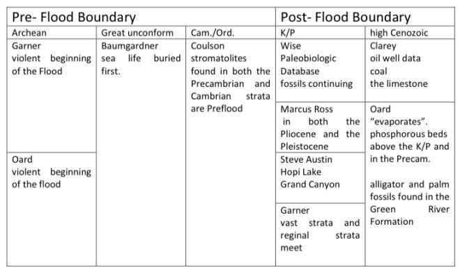
| Archean | Great unconform. | Cam./Ord. | ||
| Garner: violent beginning of the Flood Oard: violent beginning of the Flood | Baumgardner: sea life buried first. | Coulson: stromatolites found in both the Precambrian and Cambrian therefore, strata are Preflood |
There are three held positions for the Preflood boundary:
- Where the granite and sedimentary rock meet within the Precambrian,
- At the Great Unconformity,
- Between the Cambrian and the Ordovician.
Paul Garner believes the Preflood boundary should actually be within the Precambrian. He said Scripture should be used to show the epoch events and that stratum varies according to the event. The violent beginning of the Flood would be marked by sedimentary strata on granite. Mike Oard also believes in a low Preflood boundary. He said the violent beginning of the Flood ground down to where the granite is today. He said that if there had been Preflood sedimentary layers, they would not have survived the early Flood. Therefore, the Precambrian strata we have today had to have been formed during the Flood.
The Bible states that on the same day every fountain of the deep burst open, the windows of heaven were opened, and it rained for 40 days and nights, calling the beginning violent would not contradict the Bible. Seeing how normal wave action quickly turns coral, shells, even lava into sand, as was observed on the Island of Surtsey, then the violent beginnings of the Flood should have produced sand and other sediments as well. The Precambrian contains strata of limestone, thick strata of rippled sand that became quartzite, even strata containing rounded boulders of quartzite, evidence of grinding mudflows and violent wave action. If the boundary is lowered to the Archean, then these sediments would have been produced during the violent beginnings of the Flood, and then laid as the violence subsided.
Although Dr. John Baumgardner believes the Great Unconformity marks the beginning of the Flood with sea life being buried first, I think these dots connect best if the Great Unconformity marks the beginning of a new stage of the Flood instead of the beginning of the Flood. Seeing how it is rare to find a complete sand dollar or even many intact sea shells after they have been wave tossed onto the beach, it seems illogical to think that invertebrate sea-life remained intact during the beginning Flood stage. I think the invertebrate fossils of the Cambrian which starts with the Great Unconformity are the remains of sea life that was quickly yet gently buried. In my opinion, it is more logical to view them as the remains of the sea life that was reestablished after the 40 days of violently erupting fountains and rain had stopped (see Genesis 8:2).
Dr. Ken Coulson has done an extensive study of stromatolites (large colonies of fossilized bacteria) found in both the Precambrian and Cambrian strata. He believes the yearlong global Flood would not have been enough time for the formation of the stromatolites and therefore they must be Preflood. However, bacterium multiplies exponentially as shown by the frequent cyanobacteria blooms (blue-green algae) in Lake Erie. Even though winter temperatures leave the water clear and clean, these blooms can grow rapidly and are a common occurrence by late summer. Colonies of bacteria could have quickly grown within the water saturated, newly laid strata of the Precambrian and on into the Cambrian only to become fossilized in place becoming stromatolites. Again, the violent beginning would have ripped apart the colonies of bacteria if they were Preflood. Also how and when would the Cambrian strata have formed Preflood? This dot would also connect best by lowering the Preflood boundary.
It is here that I would like to add my own dot. Genesis 8:1 mentions how God created a wind. Wind is generated by variation of temperature. The Precambrian contains faulting and volcanic activity which happened after the strata had been laid. I believe this faulting happened at the start of the receding stage of the Flood. I think that when God broke the earth’s foundation, He also tilted the earth to its present 23.5 degrees throwing one pole into darkness while the other into total light. This would have caused a wind generating temperature variation. The faulting plates would have generated underwater mudflows which would have concentrated and buried the invertebrate sea life creating the Cambrian strata.
So, I would connect the dots by lowering the Flood boundary to the Archean which would mark the violent beginnings followed by the Cambrian explosion which was formed from the buried remains of the reestablished sea invertebrates. Bacterial colonies would have then grown within the strata of both the Precambrian and the Cambrian.
Meanwhile:
- fish were thriving;
- sharks were feasting;
- dinosaurs were dying and sinking;
- trees were floating;
- vegetation was beginning to sink;
- minerals were precipitating;
- mammals were swimming, floating and riding on logs mats. Once dead their bloated bodies could have continued to float, which brings us to the Postflood boundary.
Part Three: Postflood Boundary
| K/P | high Cenozoic |
| Wise and Marcus Ross: Paleobiologic Database fossils continuing in both the Pliocene and the Pleistocene Steve Austin: Hopi Lake Grand Canyon Garner: vast strata and regional strata meet | Clarey: oil well data coal and limestone Oard: “evaporates”. phosphorous beds above the K/P and in the Precambrian alligator and palm fossils found in the Green River Formation |
Two main points were made for the K/P boundary. Paul Garner said the continental strata were laid during the Flood while regional strata are Postflood. Therefore the boundary should be on top of the continental strata and beneath the regional. The second point was the continuation of species found in both the Pliocene and Pleistocene within the same general location. In other words, Postflood animals should not leave the ark and go live on the graveyards of those from the Flood. This point was made by both Dr. Kurt Wise and Dr. Marcus Ross. Even though Dr. Steve Austin’s presentation was not focused on the Flood boundary, but on the transgressive terraces of the ancient Hopi Lake and its quick draining which carved Grand Canyon. I think he would draw the Flood line at the K/P boundary, since he thinks Hopi Lake was Postflood.
Dr. Tim Clarey believes the Flood boundary should be drawn high, between the Pliocene and the Pleistocene. He based his boundary on geological data gathered from thousands of oil well core samples. He believes there is too much sediment, especially limestone and coal, in the Tertiary for it to have formed Postflood*. Mike Oard also believes the boundary should be drawn high due to the huge volume of sediment, especially “evaporates”. He believes these were actually formed from precipitation from the Flood waters, not left by evaporation. He pointed out that phosphorous beds, which are mostly found above the K/P and in the Precambrian, supports both the lower Preflood boundary and the higher Postflood boundary. He particularly pointed out that the high elevation alligator and palm fossils found in the Green River Formation were from the Flood.
These are all very logical, research based points, but they contradict each other. Why and how would Postflood animals return to the same locations that the Preflood animals had been buried? But, on the other hand, how did the vast amount of limestone, coal and precipitates like phosphates form Postflood? Is there any way to reconcile these conflicting points and connect the dots?
When it comes to the extensive strata, I think Mount St Helens may hold the key. Just like the sediment varied as it filled the Toutle River Valley during Mount St Helen’s eruption, depending on the stage of the eruption, so earth’s strata would have varied in size and composition depending on the stage of the Flood. So, continental strata becoming regional could mark the beginning of another Flood stage, rather than the end of the Flood. When the earth was eroded smooth beneath the global sea, the strata would have been continental. But, as God raised the mountain chains, the sediment would have slid off becoming regional strata filling the valleys and spreading out upon the plains. Currents would then carve windbreaks through the mountains making more sediment which would make more regional boulder filled strata.
Dr. Steve Austin’s presentation on Hopi Lake and the carving of Grand Canyon also seems to point to a lower Flood boundary. However, as the Flood retreated there would have been a point in time when the earth would have seemed to be covered by many mega lakes separated by mountain ranges. As the water continued to drain, transgressive terraces would have formed around the “lake shores”.
The continuation of species found in both the Pliocene and Pleistocene within the same general location and the vast amount of limestone, coal and precipitate are very difficult dots to connect. The vast amount of limestone, coal and precipitate do seem to indicate a need for a higher Flood boundary. But, if the line is drawn between the Pliocene and Pleistocene, how can the fossils be reconciled? The Postflood animals should not have left the ark and traveled across the globe to live on the graveyards of those from the Flood. As in logic puzzles, there must be a solution.
And here I will add another dot of my own. If the line is drawn at the K/P border, then that means the dinosaurs were buried during the Flood but the mega mammal fossils were somehow formed Postflood. Mammals leaving the ark and traveling across the globe only to be buried and fossilized after the Flood has its own set of difficult questions.
- Where are the fossils of the mammals that died during the Flood?
- Why would dinosaur fossilization require the Flood, but not mega mammal fossilization?
- Why are there only African and Asian elephants today, when there are a variety of elephant fossils found all over the world? How did the Ice Age cause a bottleneck of the elephant kind and location?
- How did all the mammals manage to become so widely dispersed from the ark?
- How did they cross mountains?
- What did they eat during the dark, cold, Siberian winter?
- Hannibal attempted to bring 37 war elephants across the Alps, but only one survived.
- How did the Ice Age cause continental, yet not worldwide, extinction? At least a few of the camels, horses and elephants in North America should have survived and repopulated North America after the Ice Age.
Maybe the boundary actually belongs above the Pleistocene. What if all the mammal fossils, like the dinosaur fossils are the remains of animals that died during the Flood?
When I work the logic puzzles, I do not try to make one continuous line. I make a lot of short connections and then return to connect those lines. That is what needs to be done here. We are going to leave these dots and jump to another part of the puzzle.
It is time to add one more dot, this one is not about the Flood boundary per say, but it is relevant to the topic. Dr. Steve Gollmer presented his computer simulation work on a rapid ice age and ice sheet growth. His main point seemed to be that he could not get the ice sheet to build during the 300 years following the Flood. Many problems kept occurring, some of which were: the snow would fall over the ocean, the ice would also build in Siberia, or the ocean would freeze preventing evaporation.
Years ago the creation movement as a whole dismissed the Canopy Theory. (For the record, I do not agree with that dismissal, but that is a topic for another article.) The dismissal does show how creation scientists were willing to release their hold on a long standing view. Perhaps it is time now to consider dismissing the Ice Age Theory. The dots connect if the boundary is raised so that all the mammal fossils, like the dinosaur fossils are the remains of animals that died during the Flood. Of course there would be a continuation of species found in both the Pliocene and Pleistocene within the same general location if they were all buried during the Flood.
The geological evidences for the Ice Age can also be interpreted as being formed by underwater muflows or avalanches. Sand avalanches in the Monterey Canyon, off the coast of California, form structures so similar to moraines that the avalanches are referred to as “sand glaciers.”1 While secular scientists believe there were five major Ice Ages, some creationists say the earlier four were actually Flood deposits.2 If the earlier four were caused by the Flood, couldn’t the fifth be as well?
One of the main solutions the Postflood Ice Age provides is the creation of land bridges needed for mammal migration. This, however, is an idea borrowed from secular science. From a Biblical perspective there is no need for land bridges. If Noah had the capability needed to build the ark, surely his descendants, who had the capability of building the Tower of Babel, could have built sea worthy boats. Just as the Spanish brought horses to America, so the people migrating from the Tower of Babel would have brought animals along too. When some groups reached the sea, they would have built boats and traveled on bringing their animals with them.
In summary: Due to the violent beginnings of the Flood, which would have produced much sand and other sediments, I think the Preflood boundary should be placed between the granite and the first sedimentary strata. The Great Unconformity would then mark the beginning of a new Flood stage rather than the beginning of the Flood and the bacteria grew insitu once the strata were laid. As for the Postflood boundary, due to the large amount of limestone, coal, and phosphate deposits, the boundary needs to be raised much higher than the K/P boundary. But the line can not be drawn between the Pliocene and the Pleistocene due to the continuation of fossils throughout the Pliocene and the Pleistocene, therefore I think the most logical placement for Postflood boundary would be above the Pleistocene. I think that mammal bone beds were formed from animals that drowned during the Flood. So, just as in the logic puzzles, the dots are connectable, just not always in the way we originally think the lines should be drawn.
*A note about the capitalization of Preflood, Flood and Postflood: just as Precambrian is a specific time period and is capitalized, I think that since the Preflood, Flood and Postflood are also specific time periods they too should be capitalized.
Find out more …
- About The Estells
- Another possible solution for disharmonious associations in Ice Age deposits
- Articles
- Connecting the Dots
- Contact information
- Creation based VBS
- Creation Resources
- Crinoid Fossils: Evidence of Millions of Years or the Global Flood?
- Did Winter Cleanse the Flood Water of Excess Salt?
- Do Antarctic Fossil Forests Prove Trees Grew near the South Pole?
- Educational Resources
- Fish Fossil
- Fish Fossils
- Geodes: Crystals Hidden Within a Round Rock
- Geology Explained in Terms of Global Flood Recovery
- God’s Forgotten Promise
- Living Fossils
- Making logical sense of earth’s geological column.
- Mount Saint Helens
- Mount Saint Helens
- Petrified Wood
- Petrified Wood
- Post Flood Migration of Mammals
- Printed Letters to the Editor
- Resources
- Reverse Engineering the Grand Canyon
- Seeing God’s Ingenuity in Earth’s Design
- Seminar descriptions with Fliers and Bios
- Seminar Topics
- sliderImages
- Songs and Poems
- Tapirs, Endangered or Hardy Survivors?
- The Demise of the Mammoths
- The Flood
- The launching of our creation ministry
- The Overlooked Flood Stage
- The Rewriting of Paradise
- The Rocks Speak Out
- The Stones’ Story Retold
- The Stones’ True Story
- The Way of Salvation
- Videos
- Was there an Ice Age?
- Whale Falls: Present Key to the Abundance of Sea Invertebrate Fossils